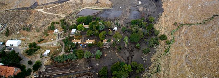
 Aerial view of a rural settlement swamped by mud and debris from the Oak Creek watershed in Inyo County. Learn more about this event in Special Report 225: The Oak Creek Post Fire Debris and Hyperconcentrated Flows of July 12, 2008. Click the image to view the entire scene.
Photo credit: Ken Babione.
Aerial view of a rural settlement swamped by mud and debris from the Oak Creek watershed in Inyo County. Learn more about this event in Special Report 225: The Oak Creek Post Fire Debris and Hyperconcentrated Flows of July 12, 2008. Click the image to view the entire scene.
Photo credit: Ken Babione.
Postfire Hazard Assessments
California Geological Survey / CAL FIRE Watershed Emergency Response Team (WERT) postfire hazard assessments: Reports prepared rapidly postfire that document and communicate postfire risks to life and property posed by debris flow, flood, and rockfall hazards.
U.S. Geological Survey Post-Wildfire Debris Flow Hazard Assessment Viewer: View emergency assessments of post-wildfire debris flow hazards for recent wildfires. Provides basin-level information on debris flow likelihood and volume for a given rainfall intensity as an interactive map as well as downloadable GIS layers.
Burned Area Emergency Response (BAER) Team reports: BAER assessments evaluate postfire hazards and determine the need for and prescribe postfire treatments for federal lands. These assessments seek to minimize threats to life or property resulting from the effects of a fire or to stabilize and prevent unacceptable degradation to natural and cultural resources. BAER reports are available through Inciweb by searching for the wildfire of interest.
Preparedness and Mitigation for Postfire Hazards
CGS Factsheet: Floods and debris flows following wildfire. A guide for the public on postfire flood and debris flow hazards.
CGS Guía: Inundaciones y flujos de escombros después de un incendio forestal. Información para el público.
CGS Factsheet: Geohazards following wildfire: Information for Emergency Management. A guide for emergency managers, first responders, and resource managers providing an overview on postfire hazards, available resources, and landscape recovery.
Riverside County Homeowner’s Guide for Flood Prevention and Response: An overview of mitigation options available to homeowners. These options are suitable for addressing floods and minor debris flows following wildfires.
U.S. Geological Survey Postfire Debris Flow Hazards Fact Sheet: Tips to keep you safe from postfire debris flows from the USGS. Disponible en español.
National Weather Service Los Angeles/Oxnard debris flow page: Information and resources for postfire debris flows from the National Weather Service Oxnard forecast office.
CGS Map Sheet 69: Prefire Modeling of Postfire Debris-Flow Hazards in California. This map depicts expected annual probability of wildfire followed by a postfire debris-flow triggering rainfall in the year following fire.
California Silver Jackets Flood After Fire California Toolkit: A resource for technical specialists to assess flood and debris flow risk after a wildfire. The resource was developed by the U.S. Army Corps of Engineers multi-agency Silver Jackets working group.
Prepare a Go-Bag: CalOES resource for creating a go-bag to be prepared for an evacuation.
Sign up for emergency alerts in your county from CalOES Wireless Emergency Alerts website.
Find a Licensed Engineer or Geologist
Department of Consumer Affairs License Search: You may want to hire a California-licensed geologist to discuss potential postfire hazards or a licensed engineer to discuss engineered mitigation options. Use this website to verify they are currently licensed in California as a Professional Geologist or Professional Engineer.
Weather Forecast Information
National Weather Service Weather and Hazards Viewer: View map of current weather hazards as well as current weather observations.
National Weather Service: Click on your area on the map to get to your local National Weather Service Forecast office. The National Weather Service is the official source for post-wildfire flood and debris flow watches and warnings.
Modeling Postfire Hazards
U.S. Geological Survey Post-Wildfire Debris Flow Hazard Assessment Viewer: View emergency assessments of post-wildfire debris flow hazards for recent wildfires. Provides basin-level information on debris flow likelihood and volume for a given rainfall intensity as an interactive map as well as downloadable GIS layers.
Inundation and runout models: These models help to predict where and how far debris flows will travel, the depth of inundation, and what the impacts may be. Read more about research and development of postfire runout and inundation models from the US Geological Survey:
Flood modeling: Various modeling resources are available for evaluating flood hazards in postfire environments. WERT assessments often include rapid, empirical modeling approaches to assess flood potential. For more detailed assessments, CGS uses the US Army Corps of Engineers Hydrologic Engineering Center River Analysis System (HEC-RAS) and Hydrologic Modeling System (HEC-HMS) to evaluate flood hazard.
Burn Area Recovery
To evaluate burn area recovery, CGS uses field observations of vegetation conditions and rainfall runoff responses as well as satellite remote sensing of vegetation conditions. The USGS has published several articles on evaluating burn area recovery with satellite remote sensing:
General Information
U.S. Geological Survey Landslide and Debris Flow Event Summaries: Geo-narrative summaries of recent impactful postfire debris flow and landslide events.
U.S. Forest Service Burned Area Emergency Response (BAER) program: A brief description of BAER evaluation and rehabilitation process for federal lands following a large wildfire.
National Interagency Fire Center description of federal Burned Area Emergency Response (BAER) program: A description of BAER evaluation and rehabilitation process for federal lands following a large wildfire.
Database of postfire debris flows in California: CGS developed a 25-year database of observed postfire debris flows in the State of California and will continue to monitor postfire debris-flow events into the future.
Back to the Burned Watershed Geohazards home page
Web page by:
California Geological Survey - Burned Watershed Geohazards Program
